What is GIS?
Geographic information systems (GIS) are used in a wide range of academic and applied fields. Simply put, GIS allows you to combine tabular data (e.g. a spreadsheet) with geographic boundaries (e.g. maps).
Read this article to learn more about mapping and GIS.
Many thanks to Miss Martin and Carleen for your feedback and the article link.
Learn More about GIS
Learn more about GIS at the sources listed here:
How does GIS work?
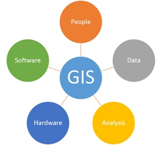
People: People use GIS to answer specific data-related questions. People collect data, develop procedures, identify research questions and define analysis tasks to run in GIS.
Data: There are two main GIS types: vector data and raster data.
– Vector data includes spatial features (points, lines, and polygons) and attributes about that data (descriptive information).
– Raster data are stored electronic images (e.g., pictures taken as an aerial photograph or satellite images).
Analysis is the process of using spatial data to answer questions. There are many different analysis techniques.
Hardware: GIS software is run on computers. Memory and computing power are important because spatial data includes many attributes making it very large.
Software: Geographic Information Systems require specialized software. The most common GIS software include ArcGIS and QGIS. These types of programs can be used in conjunction with other types of software such as databases, statistical packages, or programming languages to increase functionality.
